The state department of transportation (DOT) maintains thousands of miles of roads, which involves large expenditures for planning, design, construction, and maintenance. To achieve this, the DOTs publish reports that contain roadway data and mileage statistics.

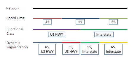
One of the most common reports is the segment report in which the events on a route are dynamically segmented together into one record set. The segment report returns separate records at any measure along the event where any of the attributes change. Segment reports can have multiple use cases depending on the needs of an organization and can provide the basis of analysis to evaluate legislation, policy, and budget options. Some examples of segment reports include the following:
- Report road conditions against other variables such as traffic and jurisdiction to determine the allocation of funds for maintenance.
- Report linear assets such as bridges against other variables such as traffic, speed limit, and urban area boundary to support planning.
- Provide a check to ensure HPMS data accuracy along a route.
About Roadway Reporter
Roadway Reporter (RR) innovates the reporting process by providing an interactive user experience to configure and publish segment reports. The application enables data stakeholders to easily access reports from a PC or tablet device to support planning and analysis needs. Report configurations are stored in your organization's Portal for ArcGIS account so that they can be easily accessed by portal members. To learn more about Roadway Reporter, see An Overview of Roadway Reporter.
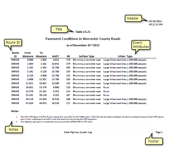
The following is an example of a segment report that has been published using Roadway Reporter. The report has been configured to dynamically segment annual average daily traffic (AADT), international roughness index (IRI), surface type, and urban type on route SR9WB:

Creating segment reports with Roadway Reporter
Roadway Reporter (RR) provides the functionality to create and save segment reports using a novel interactive spatial approach. The reports are generated for a snapshot in time using the Esri Roads and Highways networks and internal events.
To produce a segment report, you'll need the following Esri Roads and Highways LRS layers:
- Network Feature Class
- Internal events such as functional class, speed limit, surface type, urban type, jurisdiction, and so on
- Administrative polygon layers such as county boundaries, city boundaries, and so on